Hand-Drawn Maps
Capture what matters most
Custom illustrated maps made with a designer’s eye and a landscape architect’s understanding of place.
I create custom hand drawn maps for businesses, brands, places and people.
Many designers can make a map look beautiful, I can also make maps that are accurate, professionally considered and true to how a place feels. This is because I have trained and worked in both Landscape Architecture and Graphic Design. Having this combination of experience and understanding is unusual and means I bring something different to every map I make.
Click on these links to find out more about my place making maps and illustrated business maps.

Place Making Maps
Clarity, character and impact
For professional place makers, such as Landscape Architects and Urban Designers, hand-drawn maps are appealing, specific and characterful. Detailed, hand-drawn, illustrated maps can communicate important, technical information clearly and creatively, making complex ideas easy to understand.
With my background in both graphic design and landscape architecture, I understand the nuance and needs of a custom site plan or map and will work closely with you to create a map that draws viewers in and engages people in an idea as well as leaving a favourable and memorable lasting impression.
A hand-drawn map can still include all the necessary technical elements but is softer and freer by design becoming a more emotional piece of work created that can be easily understood by a wide audience.
A hand-drawn map can help to promote an idea to a client, community or stakeholder and highlight key elements of a project whilst setting the work in the wider landscape context.
Map visuals can further be used across reports, consultations and project promotion to create a cohesive and clear message from the design team.
Custom maps and site plans:
Enhance a project’s visual appeal
Make sites and ideas easier to understand
Communicate directly to general public
Build a story behind the design
Stand out from competitors
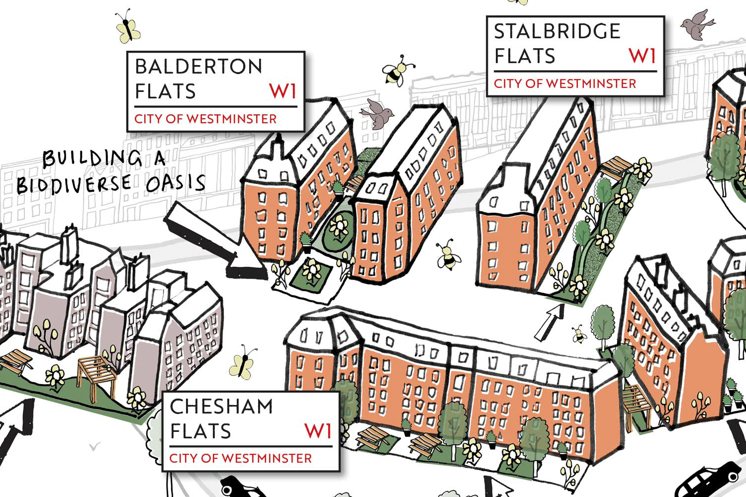
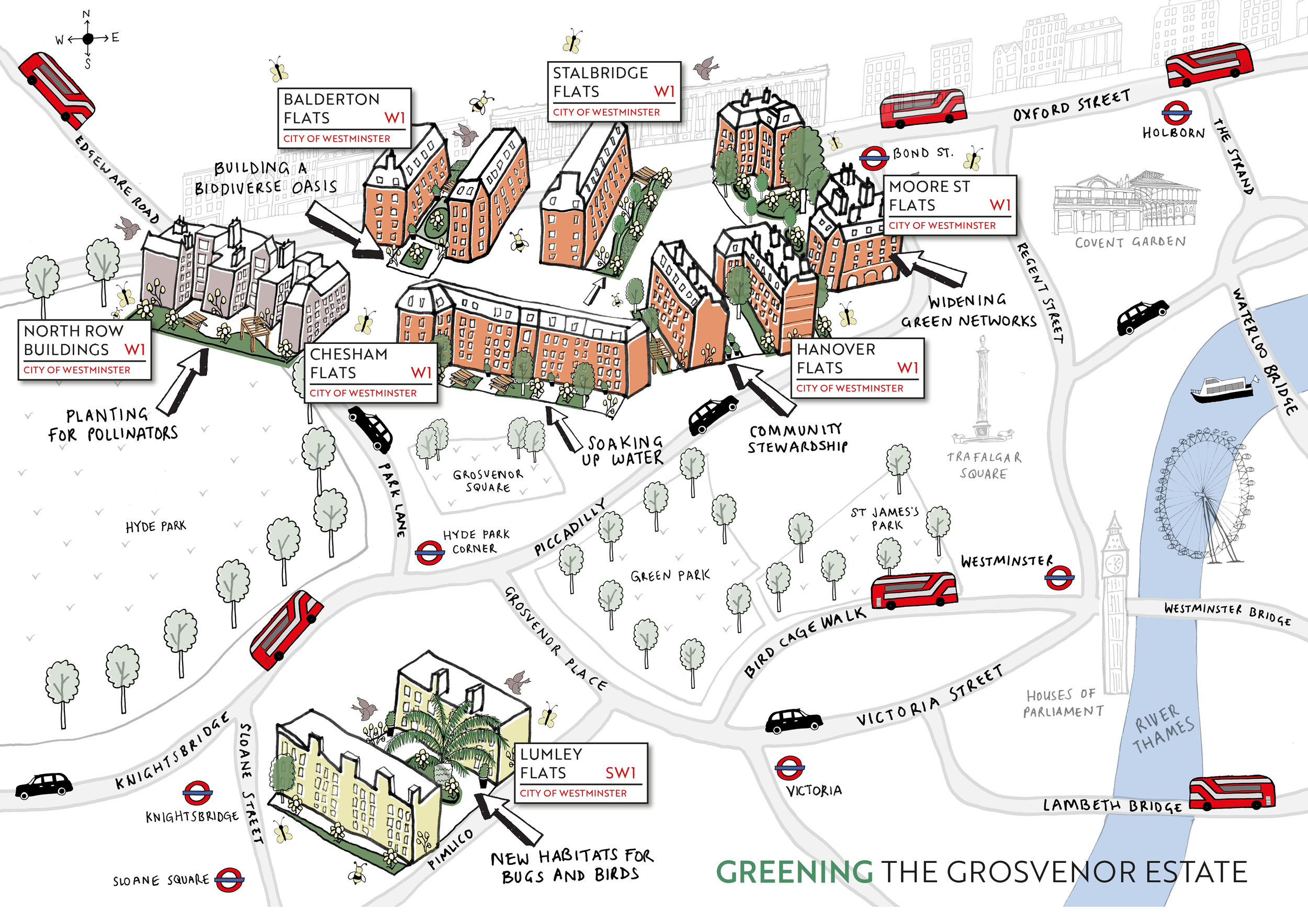
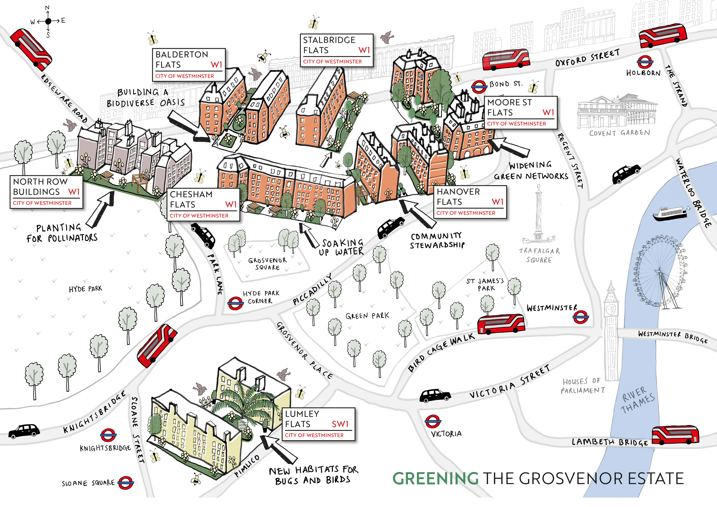
Greening the Grosvenor Estate
The above map was commissioned by the London based Landscape Architecture firm Turkington Martin. The brief was to create a highly-detailed drawing of 6 project sites across London. The map needed to encourage people to delve into it and spend time absorbing all the information across the map.
Illustrated Maps for Businesses
Creative connection
A custom illustrated map is a great way to showcase your business.
Custom maps are distinctive and engaging, providing brands and businesses with appealing, stylised visuals that can be used to enhance a company’s visual communication.
A bespoke map offers professionalism and personality to customers and clients in a way that a standard digital maps simply can’t.
Businesses can use a bespoke map as branded visual material to market their company to a wide audience, across social media, the digital realm and printed literature.
A map can also be used in a variety of ways - to highlight your business premises or retail location, guide visitors around a site, as way finding devices, or to communicate a brand’s story visually.
Whether used in print, digital media or presentations, an illustrated map creates engaging and appealing content that helps a business stand out.
A simple location map can even become a part of the brand experience, giving businesses a great visual asset to enhance promotional literature, presentations and of course social media content, whether you use Facebook, Instagram, LinkedIn or Pinterest.
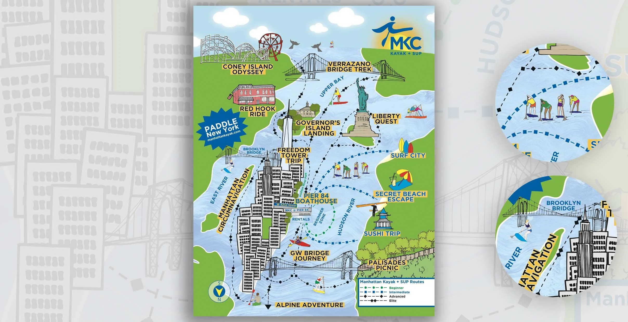
Stand Up Paddle Board Route Map
This bold and colourful map was commissioned by the Manhattan Kayak Club to advertise and illustrate the guided kayak/stand up paddle board routes they offer on the Hudson River. Starting from Pier 84 the map had to show the various routes and destinations available to customers.
Custom Maps make great visuals:
Strengthen brand identity, especially on social media
Make locations easier to understand
Enhance websites, signage and printed materials
Highlight key features, attractions, or routes in a clear and engaging way
Stand out from competitors with something unique and visually distinctive
Selected Case Studies
Project map detailing biodiversity measures being implemented across a range of sites in central London.
URBAN DESIGN MAP COMMISSION
Place Making Map
Brief: Create a hand-drawn illustrated map that sparks conversation and draws viewers in.
Turkington Martin, a firm of Landscape Architects based in London commissioned me to create a hand-drawn map depicting the work they were doing to ‘green’ residential properties within The Grosvenor Estate.
The map needed to locate the buildings in central London, depict the biodiversity work happening in each of the blocks and crucially attract attention to the project.
I spent time drawing and redrawing the base map so that the sites were the focus of the illustration whilst sitting comfortably in the wider London surrounding. Once the base map was resolved, I experimented with various ways of depicting the buildings so that the biodiversity work could be communicated logically and clearly.
Finally, I added in colour and peripheral detail such as London buses and London landmarks.
Commissioned by Turkington Martin, London
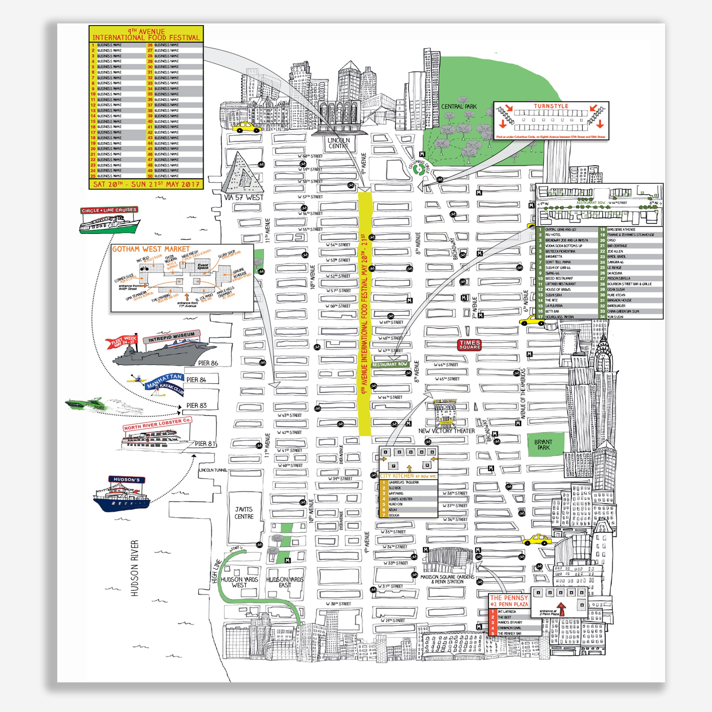
Advertising map of Hell’s Kitchen in New York for W42ST Magazine. The map had to be technically accurate whilst highlighting the business and tourist destinations in the area.
COMMERCIAL MAP COMMISSION
Neighbourhood Business Map
Brief: Create a hand-drawn illustrated map that locates businesses within the Hell’s Kitchen neighbourhood.
W42ST magazine in New York commissioned me to create a hand-drawn map of Hell’s Kitchen. The purpose of the map was to locate businesses who were advertising in the magazine. The map was printed and formed a pull-out section of W42ST which was distributed monthly in the neighbourhood. The map was constantly evolving as advertisers came onboard.
The map required the clear communication of a hefty amount of information. The drawings of New York landmarks around the edge helped to situate the map.
Commissioned by W42ST, New York.
"Sally did an amazing job working with the team at W42ST to produce the KTCHLST illustrated map. The ability to take a brief that needed a detailed map of the area with a creative flair and turn out such a beautiful illustration is remarkable"
- Phil, W42AT Magazine, New York
COMMERCIAL ENQUIRY FORM
Tell me about it, I’ll come back to you within two working days with a personalised quote.